A Bundle is already in your cart
You can only have one active bundle against your account at one time.
If you wish to purchase a different bundle please remove the current bundle from your cart.
You have unused credits
You still have credits against a bundle for a different licence. Once all of your credits have been used you can purchase a newly licenced bundle.
If you wish to purchase a different bundle please use your existing credits or contact our support team.
01:34

China: China’s BeiDou navigation system achieves breakthroughs, in-depth applications in various sectors

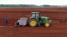
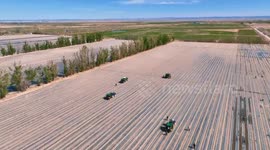
Storyline: China's BeiDou satellite navigation system has achieved major breakthroughs and in-depth applications across a wide of range of sectors, significantly boosting production efficiency. China's satellite navigation and positioning services industry, centered on the BeiDou navigation system, registered a 7.39 percent year-on-year growth to reach 575.8 billion yuan (about 80 billion U.S. dollars) in its total output value in 2024, according to a white paper released on Sunday. The white paper released by the Global Navigation Satellite System (GNSS) and Location Based Services (LBS) Association of China reported that by the end of 2024, the total number of satellite navigation patent applications in China surpassed 129,000, maintaining the country's global leading momentum in this field. The white paper showed that over 410 million satellite navigation terminals were sold in China in 2024, including 294 million BeiDou-enabled smartphones. Sales of other positioning terminal devices and systems, including the Internet of Things, wearables, vehicles, and high-precision applications, exceeded 120 million sets. With the continuous growth of satellite navigation equipment sales, many Chinese navigation map suppliers have officially switched to prioritizing BeiDou positioning. BeiDou has also achieved significant breakthroughs across a wide of range of sectors including transportation, power and mass consumption, significantly enhancing the capability level of high-precision positioning services, according to the white paper. In transportation, over 13.5 million BeiDou-enabled devices were used in road transport, postal and express delivery automobiles and rail systems by the end of 2024. Meanwhile, at ports, autonomous trucks using BeiDou navigation system enhanced operational efficiency by 25 percent. In the energy sector, over 500,000 BeiDou-supported devices are adopted, providing reliable and precise high-precision location services for inspection equipment, which has significantly enhanced the efficiency of electricity transmission and hazard identification, according to the white paper. The agricultural machinery equipped with the BeiDou navigation system has also helped farmers improve efficiency and promoted smart planting across the country. In Nanniwan, a high-quality rice production base in Yan'an City, northwest China's Shaanxi Province, BeiDou-supported unmanned transplanters have been put into use for the first time this summer. Compared with traditional ones, these unmanned transplanters can not only control the distance between plants within centimeters, but also reduce the number of manpower from some five persons to just one. The Nanniwan base also adopted drone fertilization during this year's cultivation season, comprehensively enhancing the farming efficiency. In addition to domestic applications, the overseas market of BeiDou navigation system has also continued to expand. As a core supplier of global satellite navigation systems recognized by the United Nations, BeiDou has joined the standard systems of 11 international organizations in the areas of civil aviation, maritime affairs and mobile communications. More than 30 African countries including Nigeria, Tunisia and Senegal have built BeiDou Continuously Operating Reference Stations. The market size of China's low altitude economy has so far exceeded 500 billion yuan, and is expected to reach two trillion yuan by 2030. The BeiDou navigation system will be integrated with cutting-edge technologies such as 5G communication and artificial intelligence for more efficient utilization in the years to come. Shotlist: FILE: China - Exact Location and Date Unknown: 1. Various of navigation system on mobile guiding vehicle running 2. Various of shared bikes supported by BeiDou navigation system 3. Various of users using mapping application to look for shared bikes 4. Animations showing navigation system 5. Screen showing navigation system Beijing, China - May 18, 2025: 6. SOUNDBITE (Chinese) Liu Dake, vice president, Global Navigation Satellite System (GNSS) and Location Based Services (LBS) Association of China (ending with shot 7): "Eleven major digital mapping service providers in China deliver more than one trillion location services and guide four billion kilometers of automobile running per day. The high-precision lane-level navigation of BeiDou has basically covered all urban and township roads across the country." FILE: China - Exact Location and Date Unknown: 7. Various of vehicles running FILE: Beijing, China - Date Unknown: 8. Aerial shots of traffic on urban roads FILE: Nanniwan, Yan'an City, Shaanxi Province, northwest China - Recent: 9. Various of transplanter in operation in paddy field 10. Worker operating on screen 11. Aerial shot of drone spreading fertilizers 12. SOUNDBITE (Chinese) Xian Lei, technician, Nanniwan planting base (ending with shots 13-14): "It used to take three to five workers three to five days to fertilize the field. With drones, the operation can be completed in just one morning, greatly improving the utilization rate of the fertilizer." 13. Aerial shot of drone spreading fertilizer 14. Aerial shot of drone landing FILE: China - Exact Location and Date Unknown: 15. Animations showing application of navigation systems. [Restrictions : No access Chinese mainland]
Categories
From the blog
Stories not Stock: 3 Reasons Why You Should Use UGC Instead of Stock Video
Video content is an essential part of a brand’s marketing strategy, and while stock footage has been a reliable go-to in the past, forward-thinking companies are looking to user-generated content for their video needs.
View post