A Bundle is already in your cart
You can only have one active bundle against your account at one time.
If you wish to purchase a different bundle please remove the current bundle from your cart.
You have unused credits
You still have credits against a bundle for a different licence. Once all of your credits have been used you can purchase a newly licenced bundle.
If you wish to purchase a different bundle please use your existing credits or contact our support team.
00:30

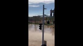
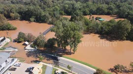
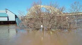
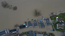
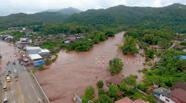
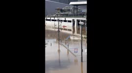
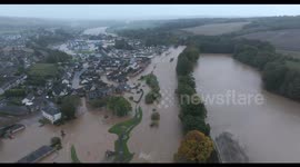
Drone Footage of flooding near the Cincinnati Reds baseball park

The Hamilton County Sheriff’s Office (HCSO) is highlighting a vital use of its Drone Operations Program beyond traditional law enforcement. Recently, HCSO teamed up with the Hamilton County Emergency Management and Homeland Security Agency to provide crucial aerial surveillance during flooding along the banks of the Ohio River. The drone footage offered emergency teams real-time intelligence to better assess water levels, monitor danger zones, and coordinate disaster response efforts more efficiently. Detectives Ken Koo and Corporal Bryan Robben were instrumental in capturing this high-quality aerial coverage, helping to inform and protect the community during a time of elevated risk.
Officials stress that while the drone footage has helped improve awareness and response coordination, public cooperation remains critical. Residents are urged not to bypass road closure signs or flood barriers, as these restrictions are in place to safeguard lives and prevent unnecessary emergencies. As flooding continues to impact parts of the region, authorities remind the public to rely on official updates and continue exercising caution around affected areas.
Categories
From the blog
Stories not Stock: 3 Reasons Why You Should Use UGC Instead of Stock Video
Video content is an essential part of a brand’s marketing strategy, and while stock footage has been a reliable go-to in the past, forward-thinking companies are looking to user-generated content for their video needs.
View post